

Tai Long Wan?! Isn’t that in Sai Kung? Yes, it is. And also in Lantau. A quick search on Wikipedia clarifies this mystery. Big Wave Bay means actually Tai Long Wan (Chinese: 大浪灣) and is the name of several bays in Hong Kong:
- Big Wave Bay, Hong Kong Island
- Big Wave Bay Beach, Hong Kong
- Tai Long Wan, Chi Ma Wan
- Tai Long Wan (Sai Kung District)
- Tai Long Wan, Shek Pik
Exactly! Today, we are talking about the beach in the south of Lantau — Tai Long Wan, Chi Ma Wan.

Like its counterpart in Sai Kung, is also this beach one of the cleanest, quietest and least crowded sandy beaches in Hong Kong. It’s located nearby the Sea Ranch Beach. It takes a bit more effort to reach that beach. You have to hike nearly 9 km to reach this hidden place.
Starting Point
As you can see in the video, I started my hike in Pui O.
There is more than one option, how to reach the Pui O Beach. I took the ferry from Central Piers to Mui Wo, and drove with the Bus to Pui O. But here are two possible ways to reach Pui O.

From Central: Catch the ferry to Mui Wo from Pier 6 at Central Ferry Pier. Once you arrive at Mui Wo, take either bus numbers 1 or 2. I propose that you keep your map open on your phone. Once you are close to Pui O, please leave the bus at the next stop. Taxis are also available at the Mui Wo Ferry Pier. However, you might need to wait quite a long time, especially on weekends. I propose to take the bus.
From Tung Chung Station: To get to Pui O, you may take the bus 3M.

The hike from Pui O to Tai Long Wan
I hiked along the coast from Pui O Beach via Mong Tung Wan towards the Sea Ranch on the Chi Ma Wan Country Trail. From there, Tai Long Wan Beach is only a few hundred meters away. I returned to Pui O via Tai Long Village and Lung Mei. From Lung Mei I chose the middle route back over the Lo Yan Shan and the Miu Tsai Tun to Pui O.
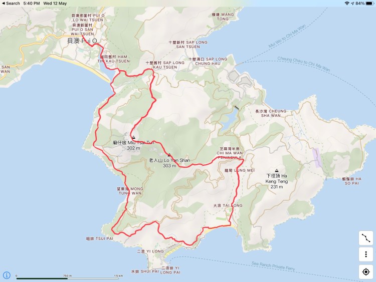
Duration, Difficulty & Distance
The trail to Tai Long Wan Beach is about 8.5 km long, although not too challenging. The trail is well-marked and can also be found easily. It becomes more difficult after Tai Long Wan Beach. Actually, Lo Yan Shan and Miu Tsai Tun are both only a few meters higher than 300 meters. Nevertheless, you walk up and down all the time. In total, I have covered almost 800 elevating meters. And many hundreds of stairs. The entire hike was 13.3 km long; the total moving time I recorded was 3 hours 20 minutes. I would classify the trek with a 5/10 — a safe trail along the beautiful coast of Lantau.


